Friday, May 18, 2018

Week 16 Final Blog for Geology 9 Pr. Garcia


Jessica Jaskiart Bhardwaj 
Geology 9 
Professor Garcia 
May 18, 2018

Week 16 
Final Hazards Report 
Country: India  

Image result for india

Hi there everyone, my name is Jessica and welcome to my very last post for Geology 9!

This class truly has been a wonderful experience and taught me how to blog. Before taking, Geology 9 I had never looked or even wrote any blogs, but it’s been fun and quite an interesting challenge. This is week 16 now, and we only have one more week left until the semester is over with. Time truly does fly by fast. By the end of this semester I will have graduated with my Associates Degree to Transfer, and will be on my way with the rest of my life. But I am extremely happy that in this Geology 9 class, I got the opportunity to study India in great depth. I was actually born there for those that may not know but I came to America when I was only 3 months old, so I don’t/didn’t know much about it. Especially in regards to natural disasters/hazards and all. 


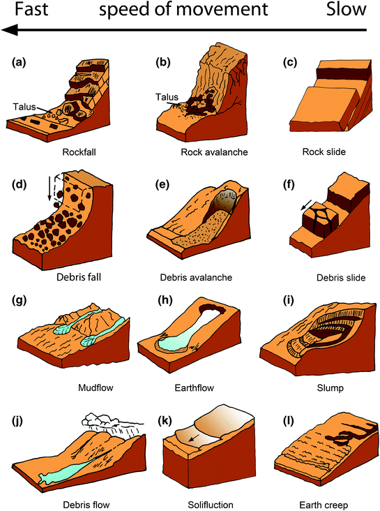
My country has had a lot of natural hazards, disasters, earthquakes, mass wastes etc…


But the most important one that I should address is the issue that my country has with water related disasters. For example: floods, tsunamis, cyclones.  The reason I choose this natural disaster is because when I was researching the deadliest natural disasters most of them all were related to water. But like I said natural disasters strike India routinely—earthquakes, tropical storms, cyclones and heat waves. But floods in India by far, have been the most damaging of all the natural catastrophes in the past last 10 years, this is data from the International Disaster Database.
Image result for floods in india people

Floods truly can cause a lot of damage and devastate homes and farms. Floods tend to displace families as well as pets and livestock, floods will damage crops, and disrupt agriculture processing and businesses.


But the real question to this is, why? Why does India experience so many water related issues, like floods? Well one of the reason's why India experiences floods is because in India there are intense monsoon seasons where it rains like crazy.  One of the latest flood/extreme waterfall story is from last August in which over 1000 people died. The rainfall brought over 300mm of water, it caused an immense of flooding in which, "Hundreds dead in India, Nepal and Bangladesh, while millions have been forced from their homes and 18,000 schools shut down across the region."-theguardian You can see how flooding is the biggest killer in India, people don't know how to even swim there. Because of floods, they're being displaced, they can not continue with their lives, its just so hard for the citizens there.


Image result for monsoon in india


What kind of recommendation can I give for the people in India? It is so hard to even think of solutions because the country just is in a certain area, where they experience so much devastation due to the monsoons. 


  • Well one thing for sure is that when Indians experience such rainfall, and are in flood zone areas they should try to get to higher ground. 
  • The Indian government should also train people on how to protect themselves, or how to prepare.
  • The government should have several rescue teams. 
  • Seal walls in houses with waterproofing compounds to avoid seepage
  • To build pipes, embankments, areas where the flood water can go, like to divert the water from the cities, away from people
  • The government should have plans for each disaster

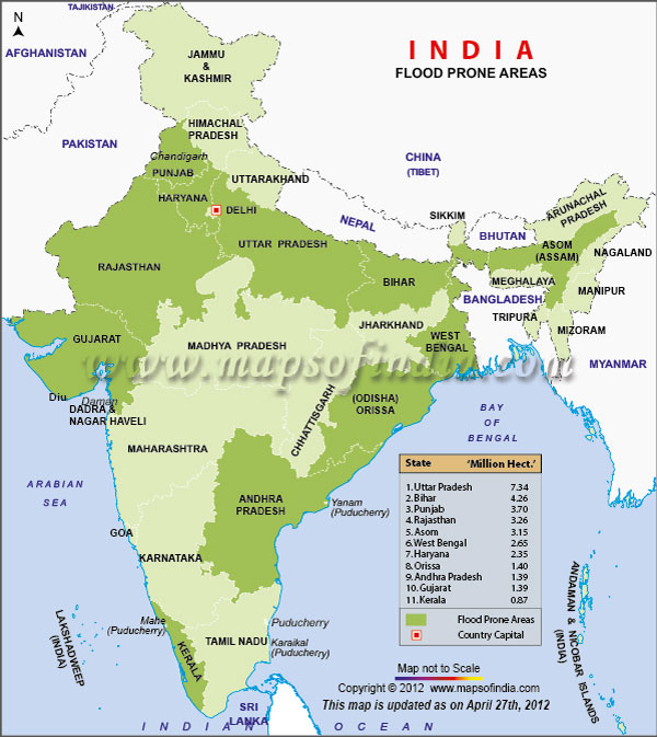
India all over experiences monsoon seasons and floods, but according to UNICEF there are five for sure states that are at risk of floods the most. Those five states are Assam, West Bengal, Bihar, Uttar Pradesh, and Orissa. The reason why these states are highly likely to experience floods is because when there is heavy rainfall, the major rivers that are nearby flood. The water has no where else to go so it comes out. These are the top areas that would need a lot of attention and care. Just because they are the riskiest states to be in. 

Image result for top ten place india floods images


What is India doing about these floods? People of India are suffering because of these floods, so the government is taking some action to try and relief the pain that the people are experiencing. Some of things that are happening are: 
  • The IFRC – working with the Bangladesh Red Crescent Society and the Nepal Red Cross – has launched appeals to support almost 200,000 vulnerable people with immediate relief and long-term help with water and sanitation, health and shelter.
  • the Government of India enacted the Disaster Management Act
  • UNICEF in line with the Core Commitment to Children provides support of the government’s relief programs during emergencies and natural calamities.
  • As part of the measures to prepare for the disasters, there is an overall master plan for every state and contingency plan for each district, involving apart from other things, steps required to be taken before the onset of floods during the floods and post- flood management.

Where would I live to avoid disasters? Or in better words where is the safest city to live in to avoid floods? That is a good question. When i saw this photo it became clear that in the middle of India, it seems to be the most safest. Yes, it had a gas problem back in 1982, but that does not seem as bad as what other states in India are experiencing. So I would say that I would live in Madhya Pradesh if I was to live in India. 


Sources:

  • Dutta, Saptarishi. “Of All Natural Calamities, Floods Are the Deadliest for India.” Quartz, Quartz, 29 Sept. 2014, qz.com/236280/of-all-natural-calamities-floods-are-the-deadliest-for-india/.
  • IndiaSpend/indiaclimatedialogue.net, S Gopikrishna Warrier. “Mumbai Floods: Why India's Cities Are Struggling with Extreme Rainfall.” Https://Www.hindustantimes.com/, Hindustan Times, 29 Aug. 2017, www.hindustantimes.com/india-news/mumbai-floods-why-india-s-cities-are-struggling-with-extreme-rainfall/story-wsWPNy2MXh4b9JYTqtA0QJ.html.
  • Siddique, Haroon. “South Asia Floods Kill 1,200 and Shut 1.8 Million Children out of School.” The Guardian, Guardian News and Media, 31 Aug. 2017, www.theguardian.com/world/2017/aug/30/mumbai-paralysed-by-floods-as-india-and-region-hit-by-worst-monsoon-rains-in-years.
  • “Preparing for the Monsoon | UNICEF.” Child Labour | UNICEF, unicef.in/Story/293/Preparing-for-the-monsoon-.
  • “Top Ten Flood Prone Areas In India.” India Large Color Map, www.mapsofindia.com/top-ten/geography/india-flood.html.

Thank you so much, and I hope you enjoy my post on India and it's hazards. Wishing everyone the best, good luck on finals and life! :) 


Jessica Bhardwaj


Friday, April 27, 2018

Week 13 Coastal Hazards/ Coastal Erosion in India

Jaskiart Jessica Bhardwaj
Geology 9
Pr. Ana Garcia
4/27/18
Week 13

Hi there everyone my name is Jessica Bhardwaj and my country for the semester is India.
This week we learned about coastal hazards and coastal erosion, and for this post I will be talking about how my country experiences coastal hazards/erosions, and what my country does to mitigate the affects of it.

My country India is surrounded by water, because of that my country faces a lot of threat from water related issues. For example, India experiences: floods/flash floods, heavy rain, tropical cyclones, thunderstorms, lightening, heat waves, coastal erosions and so forth. Around 76 percent of India’s coastline is prone to cyclones and tsunamis.

With all the water related issues, my country experiences coastal erosion because of it. In the photo below, the yellow highlighted area demonstrates which regions are the most affected. When I was researching coastal erosions and the region that is affected the most, it said that it was the West Bengal region. In one of my past posts, I mentioned how one of the deadliest cyclones in Indian history was in Bangladesh/West Bengal area, it killed over 500,000 people and the damages were over millions of dollars because of it.


See the source image

The erosion is also really bad in India, especially in the West Bengal area. Coastal Erosion by the way is the process of wearing away of the land by the sea due to corrosion, abrasion, hydraulic action, attrition and corrosion/solution. In Bengal, the Bay of Bengal has experienced 89% erosion in the Andaman and Nicobar Islands. 89% is a extremely concerning and high number, that is why my country is coming up with measures and ideas on how to help fix this problem.

The way that my country tries to minimize damage from coastal hazards is by some of these methods.
1. Construction of saline stone-packaging and breakwater structures
2. By constructing low walls called groyne
3. By installing Geo-Synthetic Tubes
4. By growing more vegetation along the coastline
4. Encouraging Social Forestry
5.Encouraging conservation activities, educational and recreational opportunities (Eco-development
 
Sources:
  • Anwar, Shakeel. “Coastal Erosion in India.” Jagranjosh.com, 23 Nov. 2017, www.jagranjosh.com/general-knowledge/coastal-erosion-in-india-1511443982-1.      
  •  

Sunday, April 1, 2018

Week 10 Country of our choice.


Jaskiart Jessica Bhardwaj
Geology 9
Professor Garcia
4/1/2018
Canada and it's Extreme Weather

This week we are leaning about extreme weather, and we are allowed to write our blogs and our research on any country that we would like. I went to Montreal, Canada last year in the summer with my sister, and I experienced some weird events, some events that are foreign to us as Californians. On our last day of our trip, it was a sunny day out, only 15 minutes later there were heavy clouds that crept into the skies, about five minutes later it started pouring so hard that doors were blown open, rain water was coming into the house, the electricity went out, there was even thunder and lightening. Then about another ten- fifteen minutes later it was sunny out again. This all happened in less than an hour! It was a crazy experience, an experience that I will never forget in my life. That is why I want to write my blog today on Canada and it's extreme weather. Here is also a link to a mini snippet that I took of the rainfall that day.


When one thinks about Canada, the first thought that comes to mind is, "that place where it snows a lot, the frozen land." Well at least that's what comes to my mind when I think about Canada. Canadian weather in reality though it very diverse and all over the place. It is not just a country that experiences below zero temperatures but it also experiences severe heat flashes during the summer, and Canada also experiences severe rainfall. Crazy temperatures aren't the only things that happen in Canada. Canada also has experienced things like tornados and sinkholes!

Annually freezing rain averages are about twenty to thirty-five hours up to fifty to seventy hours. As for intense snow storms the worst 20th century storm happened back in January of 1998 where damages totaled up to a whopping $1 billion dollars!! Did you know that Canada has the worlds largest average daily of -5.6 C? Yeah neither did I! Pretty interesting though, huh.

Another, extreme thing that Canada experiences is it's heat waves. When my sister and I went to Montreal in the summer, we did not expect it to be as hot as it actually was. Everyday the temperatures were over 80 degrees F. Oh and the humidity was awful! But the longest and deadliest heat wave that happened in Canada was a very long time ago, back in July 5-17 of 1936. The temperatures went over 44 Celsius which is 111.2 degrees in Fahrenheit! Thank God, temperatures did not rise that high when I was there.

Now, I would like to even mention a few things about Canada and the deadliest tornado that it experienced! This tornado also was ages ago but the facts behind it are interesting. Back in June of 1912, a tornado killed 40 people, injured 300 people and ruined hundreds of buildings, and it only lasted a surprising 3 minutes!

Canada also has seen sinkholes in its time. One of the biggest sinkholes that happened was in May of 1971, where heavy rain fall opened up a 600m wide and 30m deep, sinkhole! Goes to show that Canada isn't just about its wild temperatures but it also experiences other natural disasters also.

Canada experiences a lot of natural hazards that can cause a lot of damage and casualties. That is why Canada has to do a lot in order to minimize damage and mitigate disasters. Canada has national disaster mitigation strategies set in place. What these strategies do is that, it understands what the problem is, then there is leadership and coordination figured out, then there is public awareness and then there is education and outreach to the public. It is really important that the public is aware of how to avoid or be safe during a disaster.

Thank you,
Jessica

Sources:

“Extreme Weather in Canada.” 
The Canadian Encyclopedia, 16 Dec. 2016, www.thecanadianencyclopedia.ca/en/m/article/extreme-weather-in-canada-feature/.


Monday, March 12, 2018

Week 8: MASS WASTING IN INDIA

Jessica Bhardwaj 
Professor Ana Garcia
Geology 9
3/12/2018
Week 8 

Mass Wasting 


Image result for mass wasting

Image result for mass wasting

Image result for mass wasting india


Hi everyone, this is Jessica!

This week I will be talking about my country's Mass Wasting.

Mass Wasting is the movement of sediment or soil that is going downhill by gravity. First, I would like to list the different types of mass waste there are. The different types of mass wastes are: Falls, Slides, Flows, Slumps and Creeps. Falls are regolith cascades going down a slope, they can occur by being undercutted by running water. They occur at steep slopes, rock materials can get loosened by earthquakes, rain, expanding ice and other things. Slides are something like landslides, its rapid movement of large mass of earth and rocks downhill or on mountains. Can be caused by rainfall. Flows are also like, fluidly, like mudflows, avalanches, debris flows, earth flows etc... Slumps are slipping of coherent rock materials along a curved surface, when they happen it forms a crescent shape. Creeps take a while, the are a combination of small movements of soil and rock, and they go downhill, the steeper the surface, the faster creeps go down.

When I looked up what kind of mass wasting happen in India, I found out that Landslides are the most prevalent in my country. The most recent landslide that occurred in India was back in August of last year. 46 people were killed because of that landslide, two buses and a couple of houses were swept away from the hills there. There were a lot of rocks, boulders and debris that were involved in the landslide. India is always prone to landslides because there are monsoon seasons, and rainfall causes landslides. In India there is a landslide zonation map, some of the listed areas on the map are: The Western Himalayas, Uttar Pradesh, Kashmir, Jammu, West Bengal, Nagaland, The Plateau Margins, and many more. Landslides are serious problems in India, that is why there are also ways that the Indian government tries to mitigate the damage and risk.
 
Here is a quick list given by the Civil Services Preparation on how to mitigate landslides in India
  1. Excess water in catchments areas should be stored to reduce the effect of flash floods, this will also recharge the ground water level in areas prone to landslide in India.
  2. The runoff collection ponds in the catchment areas must be dug to store water.
  3. On community lands, fuel or fodder trees should be grown to increase forest cover to reduce landslide hazard in India.
  4. Grazing should be restricted and better grass must be grown on the surface previously grazed to increase the hold on soil by plant roots. These grasses can be of some commercial importance so that economic returns encourage farmers in areas prone to landslide in India.


Sources :

  • https://www.cliffsnotes.com/study-guides/geology/mass-wasting/types-of-mass-wasting
  • http://www.livemint.com/Politics/PWWZWaeFPN70bXKgh78i8K/All-you-need-to-know-about-landslides.html
  • “Landslides in India - Geography Study Material & Notes.” Exam Pariksha, 27 Jan. 2018, exampariksha.com/landslides-in-india-himalayas-geography-study-material-notes/.                                                  


Thursday, February 22, 2018

Week 5 Volcanos Geology 9 Feb-22

Jessica Bhardwaj
Pr. Ana Garcia 
Geology 9
Week 5
Volcanos
Hi everyone, this is Jessica!

This week I will be talking about my country's volcanic activity. First, I would like to define what a volcano is, according to dictionary. com, a volcano is a "a mountain or hill, typically conical, having a crater or vent through which lava, rock fragments, hot vapor, and gas are being or have been erupted from the earth's crust" My country is India, and it only has one volcano. Where is the active volcano in India? It's actually located on a island called Barren Island, also known as the Andaman Islands. Barren Island, is most easterly of the Andaman Islands, is the only confirmed active volcano in India. The island along with the rest of the Andaman's is the Andaman & Nicobar Islands, and lies some 135 kms northeast of the territory's capital, Port Blair. For the past 150 years though, this volcano was dormant, but it has started showing signs of being active once again. The volcanic island is uninhabited and its northern part is, as the name suggests, barren and devoid of vegetation. Indian citizens can visit the island by chartered boats after getting permission from the forest department in Port Blair. What is my country doing about warning its citizens regarding the volcano? Well for a very long time the volcano has been quiet and not erupted, but a few years back it triggered a earthquake which was harmful to India. Since then, a Geological Survey team has gone to the Island to asses the impacts of eruptions and the emissions that occur. There frankly is not a lot of information on how India deals with volcanic activity because it is not a major threat to them. But I am sure they take a lot into consideration, and follow the standard ways on how to deal with volcanos, since they can be disastrous at times.

A picture of the volcano
Image result for barren island volcano 
 AdamBDetailed.jpg
 
 
Resources:
 
Sayed, Nida. "India's Only Volcano Active Again - Times of India ►." The Times of India. Times of India, 18 Feb. 2017. Web. 23 Feb. 2018. https://timesofindia.indiatimes.com/india/indias-only-volcano-active-again/articleshow/57227969.cms

"Indian Plate." Worldvolcanoes - Indian Plate (2). N.p., Jan. 2009. Web. 23 Feb. 2018. https://worldvolcanoes.wikispaces.com/Indian+Plate+%282%29


Wednesday, January 24, 2018

India


By: Jessica Bhardwaj
Jan 24, 2018
Geology 9
Pr. Garcia


Differences between Catastrophes, Disasters, and Natural Hazards. 

I would like to define each one of these words before I begin differentiating between the three. A catastrophe is a major disaster that demands a lot of money and many years of constant rebuilding in order to recover from it. A disaster is defined as a hazardous event that happens over a limited time span and in a specific area. Lastly, a natural hazard is a natural event that is a potential threat to human life and to properties. 


1/29/18 
My Country on the Plate Tectonic Map 
Plate tectonics - world map with fault lines of major an minor plates. Stock Vector - 55775773

The Indian Plate is surrendered by four boundaries, the four are the Eurasian plate, the Australian plate, the African plate and the Arabian plate. Long time ago India actually was hit up against Asia, about 40 to 50 million years ago, and that caused the Himalayas Mountains to form. The Indian Plate is slowly moving up north, and scientists believe that the Himalaya mountains still grow in height till this day because of the slow movement of the plates. With the tectonic plates moving the type of hazards that may arise are like, earthquakes, tsunamis, floods and much more.

References

“Indian Plate.”                                Eurasian Tectonics, eurasiatectonics.weebly.com/indian-plate.html.

Pmf. “Plate Tectonics - Indian Plate Movement.” PMF IAS, 20 July 2016, www.pmfias.com/plate-tectonics-indian-plate-movement-convergent-divergent-boundary-comparison-continental-drift-see-floor-spreading-plate-tectonics/.


2-5-18


My Countries Seismicity


India has seen some terrible and destructive earthquakes in the past years. There are reports done by the United Nations and World Bank and if their reports are true then by the year 2050, more than 200 million people living in City-based India will be exposed to earthquakes. Nearly 54% of the land in India is likely to experience earthquakes. India is also divided into four earthquake-related zones, namely, zone 2, zone 3, zone 4 and zone 5. Zone 5 is actually the most prone to having earthquakes where as zone 2 is the zone that experiences the lowest seismic levels. There are 5 major cities that are prone to earthquakes in India. They are, Delhi, Mumbai, Chennai, Guwahati, and Srinagar. India is doing a lot of things in order to be prepared for when a disaster strikes. One way they are doing that is, that they have a Disaster Management Act, which basically states the ways institutional and coordination mechanisms for effective disaster management (DM) at the national, state, and district levels will be. They have a handbook on earthquake safety which is prepared for the general public, highlighting the safety of persons (i.e., indoors, outdoors, and driving), buildings and structures, and non-structural contents of buildings. There are also a lot of educational short films that get displayed around the country for the people of India know what to do when a earthquake strikes. Many places in India also have a early earthquake warning system, which can definitely be helpful. 


Resources  
“5 Most Earthquake Prone Cities in India.” Skymet Weather Services, 31 Jan. 2018, www.skymetweather.com/content/weather-news-and-analysis/5-most-earthquake-prone-cities-in-india/.

“India: National Disaster Management Guidelines - Management of Earthquakes.” ReliefWeb, reliefweb.int/report/india/india-national-disaster-management-guidelines-management-earthquakes.


map