By: Jessica Bhardwaj
Jan 24, 2018
Geology 9
Pr. Garcia
Differences between Catastrophes, Disasters, and Natural Hazards.
I would like to define each one of these words before I begin differentiating between the three. A catastrophe is a major disaster that demands a lot of money and many years of constant rebuilding in order to recover from it. A disaster is defined as a hazardous event that happens over a limited time span and in a specific area. Lastly, a natural hazard is a natural event that is a potential threat to human life and to properties.
1/29/18
My Country on the Plate Tectonic Map
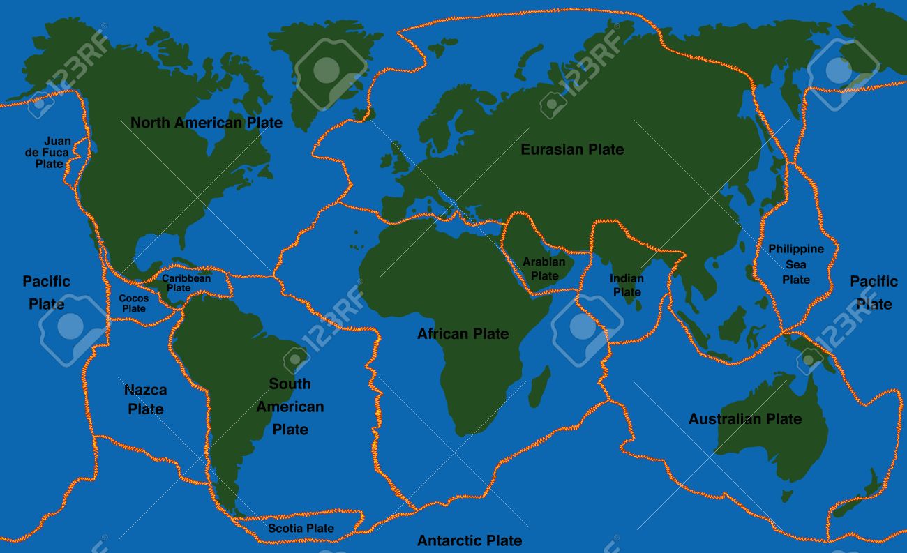
The Indian Plate is surrendered by four boundaries, the four are the Eurasian plate, the Australian plate, the African plate and the Arabian plate. Long time ago India actually was hit up against Asia, about 40 to 50 million years ago, and that caused the Himalayas Mountains to form. The Indian Plate is slowly moving up north, and scientists believe that the Himalaya mountains still grow in height till this day because of the slow movement of the plates. With the tectonic plates moving the type of hazards that may arise are like, earthquakes, tsunamis, floods and much more.
References
“Indian Plate.” Eurasian Tectonics, eurasiatectonics.weebly.com/indian-plate.html.
Pmf. “Plate Tectonics - Indian Plate Movement.” PMF IAS, 20 July 2016, www.pmfias.com/plate-tectonics-indian-plate-movement-convergent-divergent-boundary-comparison-continental-drift-see-floor-spreading-plate-tectonics/.
2-5-18
My Countries Seismicity


India has seen some terrible and destructive earthquakes in the past years. There are reports done by the United Nations and World Bank and if their reports are true then by the year 2050, more than 200 million people living in City-based India will be exposed to earthquakes. Nearly 54% of the land in India is likely to experience earthquakes. India is also divided into four earthquake-related zones, namely, zone 2, zone 3, zone 4 and zone 5. Zone 5 is actually the most prone to having earthquakes where as zone 2 is the zone that experiences the lowest seismic levels. There are 5 major cities that are prone to earthquakes in India. They are, Delhi, Mumbai, Chennai, Guwahati, and Srinagar. India is doing a lot of things in order to be prepared for when a disaster strikes. One way they are doing that is, that they have a Disaster Management Act, which basically states the ways institutional and coordination mechanisms for effective disaster management (DM) at the national, state, and district levels will be. They have a handbook on earthquake safety which is prepared for the general public, highlighting the safety of persons (i.e., indoors, outdoors, and driving), buildings and structures, and non-structural contents of buildings. There are also a lot of educational short films that get displayed around the country for the people of India know what to do when a earthquake strikes. Many places in India also have a early earthquake warning system, which can definitely be helpful.
Resources
“5 Most Earthquake Prone Cities in India.” Skymet Weather Services, 31 Jan. 2018, www.skymetweather.com/content/weather-news-and-analysis/5-most-earthquake-prone-cities-in-india/.
“India: National Disaster Management Guidelines - Management of Earthquakes.” ReliefWeb, reliefweb.int/report/india/india-national-disaster-management-guidelines-management-earthquakes.
map
Very nicely framed. A like the map, as it is very clear, and that you explain how the Himalayas formed...there are a few animations about this event. Here below is one in case you haven't seen it yet...Soo...it seems pretty clear where your countries' main quakes will be when you 'll discuss them next week....
ReplyDeletehttps://www.edumedia-sciences.com/en/media/565-formation-of-the-himalayas
Great job Jaskiart it is well written and very easy to follow. You made an excellent choice on the picture because it makes it clear on where the plate boundaries are located. Cant wait for your next post as you are keeping me informed about India. Good luck!
ReplyDeleteJaskiart, I found this information about India's tectonic plates interesting. You will most likely have quite a bit to write about with your country bounded by these four tectonic plates! I was surprised to learn that the Himalayas were still, in fact, growing due to plate movement. That was a fascinating fact. Nice, clean and easy-to-read map, too!
ReplyDeleteI really liked how clear the information is. Isn't it astonishing how the earth's plates create mountains? I am looking forward to your next post.
ReplyDeleteHi,
ReplyDeleteNice research this week.
it seems you are editing the only post you have every week, adding data to the previous week's...I'd prefer that you add a new post every week, that way, your post is time-stamped, and your classmates can comment on your blogs separately and not get confused...Let me know if you have issues doing this the next time we blog in class. See link below. Thank you.
https://support.google.com/blogger/answer/154172?hl=en